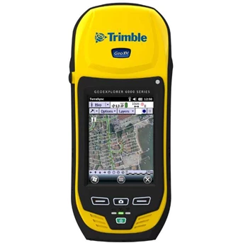
Detail GPS Trimble GeoXH 6000 Standard
SYSTEM SUMMARY
Dual-frequency GNSS receiver and antenna with Everest™ multipath rejection technology and Floodlight technology
Sunlight readable 4.2" polarized screen
Optional integrated 3.5G cellular modem
Integrated Wi-Fi and Bluetooth wireless technology
5 megapixel autofocus camera
Windows Mobile® 6.5 ( Professional edition)
Rugged and water-resistant design
SIZE AND WEIGHT:
Height:
234 mm ( 9.2 in)
Width:
99 mm ( 3.9 in)
Depth:
56 mm ( 2.2 in)
Weight ( inc. battery) :
925 g ( 2.0 lb)
GNSS:
Receiver:
Trimble Maxwell™ 6 GNSS chipset
Channels:
220 channels
Systems:
GPS, GLONASS, SBAS
GPS:
L1C/ A, L2C, L2E
GLONASS:
L1C/ A, L1P, L2C/ A, L2P
SBAS1:
WAAS/ MSAS/ EGNOS
Update rate:
1 Hz
Time to first fix:
45 s ( typical)
NMEA-0183 support:
Optional
RTCM support:
RTCM2.x/ RTCM3.x
CMR support:
CMR/ CMRx/ CMR+
GNSS ACCURACY ( HRMS) AFTER CORRECTION2:
Real-time H-Star2
10 cm + 1ppm
Real-time code corrected
Local base
75 cm + 1 ppm
SBAS ( WAAS/ MSAS/ EGNOS)
< 1 m
H-Star postprocessed
10 cm + 1ppm
Code postprocessed
50 cm + 1 ppm
Carrier postprocessed
After 45 minutes
1 cm + 2ppm
TEMPERATURE:
Operation:
-20 ° C to + 50 ° C ( -4 ° F to 122 ° F)
Storage:
-30 ° C to + 70 ° C ( -22 ° F to 158 ° F)
Charging:
0 ° C to + 45 ° C ( 32 ° F to 113 ° F)
MECHANICAL SHOCK:
Drop:
1.2 m ( 4 ft) plywood over concrete
Vibration:
Method 514.5
ALTITUDE & HUMIDITY RATINGS:
Relative humidity:
95% non-condensing
Maximum operating altitude:
3, 658 m ( 12, 000 ft)
Maximum storage altitude:
5, 000 m ( 16, 400 ft)
INGRESS PROTECTION:
Water/ Dust:
IP65
BATTERY:
Type:
Rechargeable, removable Li-Ion
Capacity:
11.1V 2.5 AH
Charge time:
4 hours ( typical)
BATTERY RUN TIME3:
GNSS only:
10 hours
GNSS & VRS over BT:
9.5 hours
GNSS & VRS over Wi-Fi:
8.5 hours
GNSS & VRS over Cellular modem:
5 hours
Standby time:
50 days
BUTTONS & CONTROLS:
Power key
Left & right application keys
Camera key
CONNECTORS & INPUTS:
Internal microphone and speaker
Mini USB connector
DE-9 serial via optional USB to serial converter
External power connector
SIM socket
SDHC card socket
CAMERA:
Still mode:
Autofocus 5 MP
Still image format:
JPG
Video mode:
Up to VGA resolution
Video file format:
WMV with audio
CELLULAR4 & WIRELESS5:
UMTS/ HSDPA
850/ 900/ 2100 MHz
GPRS/ EDGE
850/ 900/ 1800/ 1900 MHz
Wi-Fi:
802.11 b/ g
Bluetooth
Version 2.1 + EDR
DISPLAY:
Type:
Transflective LED-backlit LCD
Size:
4.2" ( diagonal)
Resolution:
480x640
Luminance:
280 cd/ m²
HARDWARE:
Processor:
TI OMAP 3503
RAM:
256 MB
Flash:
2 GB
External storage:
SD/ SDHC up to 32 GB
LANGUAGES
English ( US) , Spanish, French, German, Italian, Portuguese ( Brazilian) , Chinese ( Simplified) , Korean, Japanese, Russian
IN THE BOX:
GeoExplorer 6000 series handheld
Pouch
Hand strap
USB data cable
Rechargeable battery pack
AC Power adaptor
Screen protector kit
Spare stylus & tether
Documentation
OPTIONAL ACCESSORIES:
Vehicle power supply
Tornado™ external GNSS antenna
1.5 m & 5 m external antenna cable
Range pole kit for external antenna
Backpack kit for external antenna
Vehicle mount
Hard carry case
Null modem cable
USD to serial converter cable
Tampilkan Lebih Banyak